The Watershed Atlas  ·  No. 01 — Lower Eighteenmile Creek  ·  No. 02 — Hunnicutt Creek

Clemson  ·  Flashy — past the line

The Watershed Atlas · No. 02

Hunnicutt Creek

The creek that runs through Clemson's campus — from the Botanical Garden down to Lake Hartwell, about two and a half miles and 138 feet of drop. It's a small watershed, and one of the most built-up in the Upstate. That makes it a clear place to see what development does to water — and a hopeful place to show what fixing it can look like.

2.8 sq mi drains to Lake Hartwell (Seneca arm) 3.3 mi main stem 78% one soil group
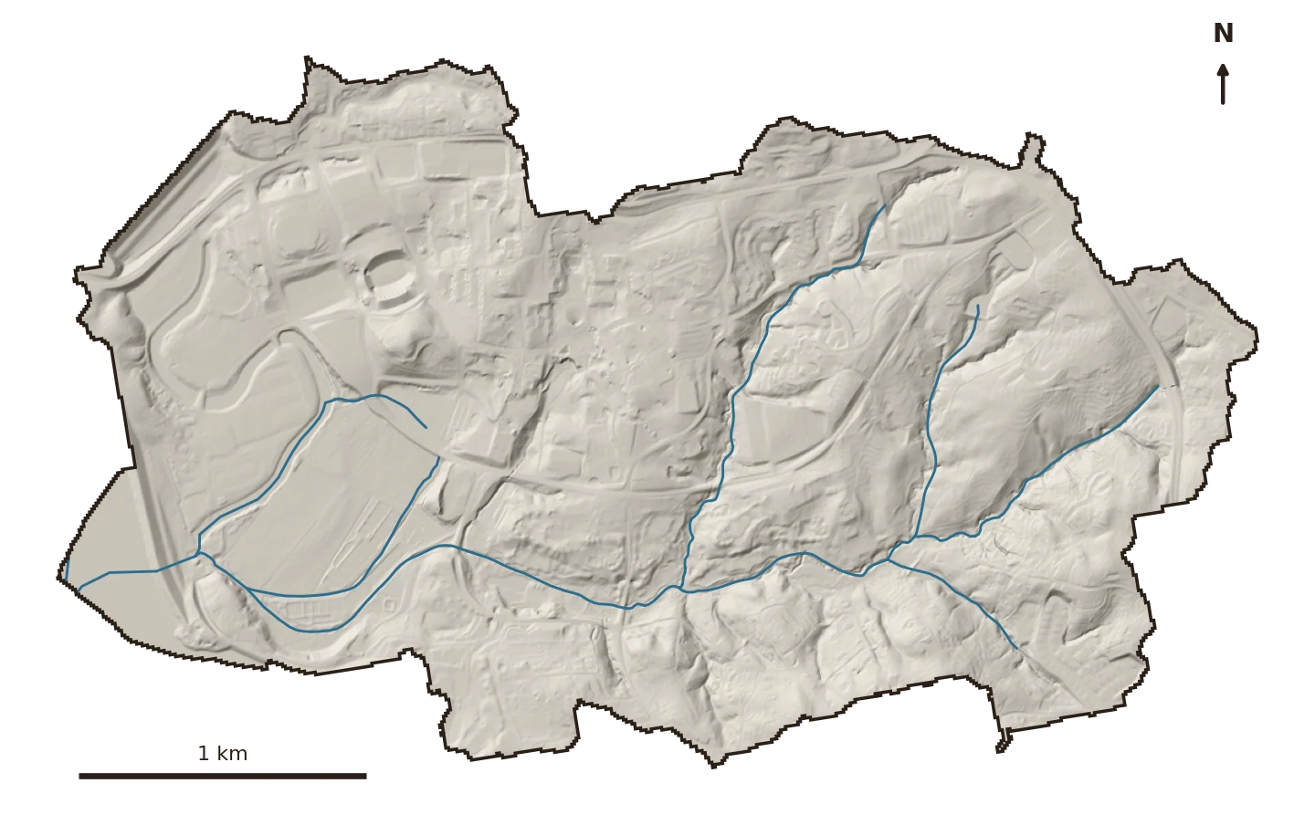
Shaded-relief terrain map of the Hunnicutt Creek watershed with its stream network in blue; the campus core and Memorial Stadium are visible as smooth built pads at upper left, the creek draining west to Lake Hartwell.
Terrain & streams · USGS 3DEP 1 m LiDAR hillshade + NHD flowlines. The creek runs west to its Lake Hartwell outlet; the built pads at upper-left are the campus core.
The ground

Piedmont clay, mostly paved over

Hunnicutt drains 2.8 square miles of Clemson — campus, downtown, and the neighborhoods between. Like its bigger neighbor Eighteenmile, it sits on old Piedmont clay: about four in five acres are hydrologic-group-B soil, so the ground drinks water at a predictable rate.

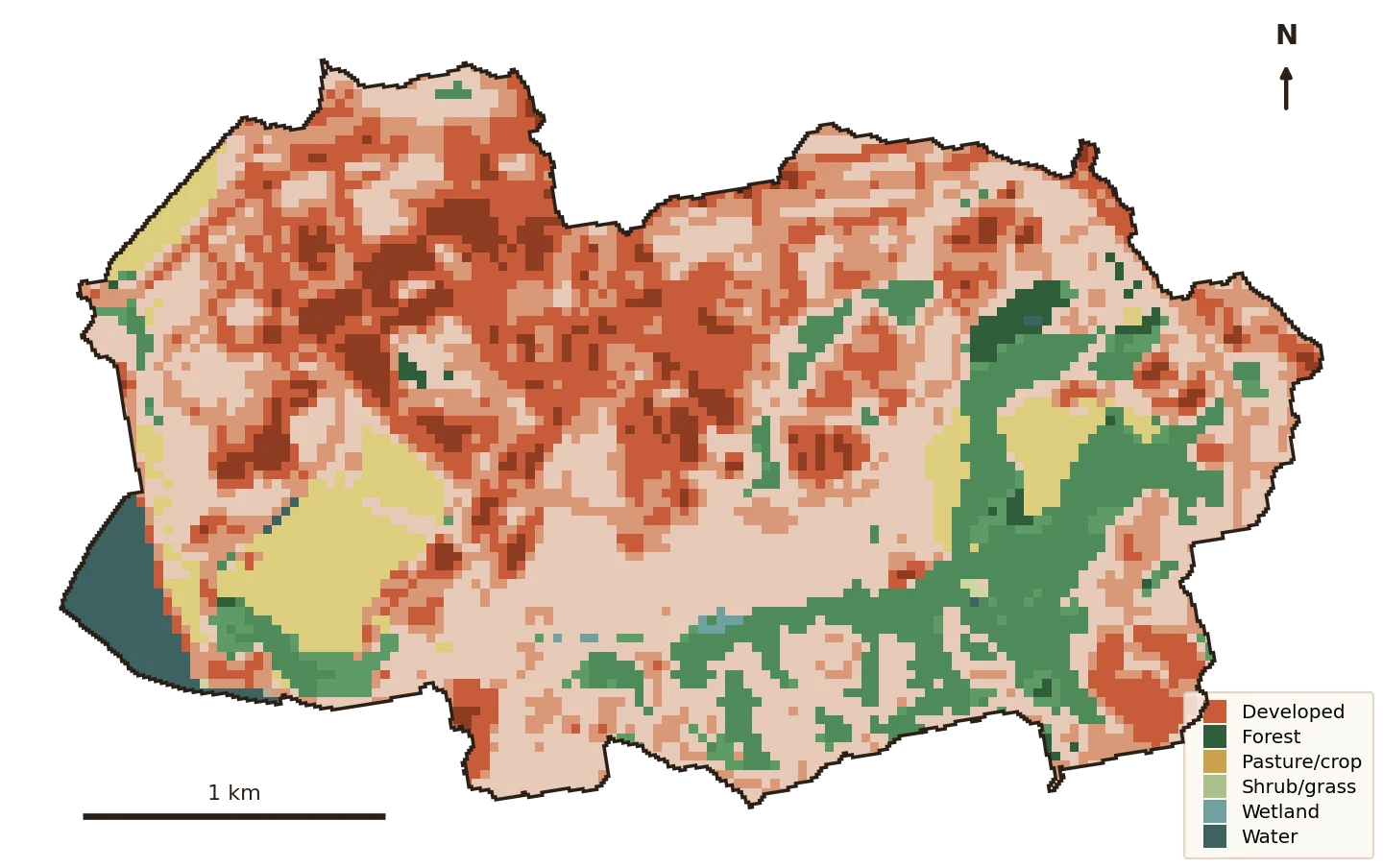
But where Eighteenmile is still mostly green, Hunnicutt is mostly built. In 2023, developed land covered about three-quarters of the watershed. That is the fact this whole page turns on.

76.2%
Developed land, 2023 — up from 57% in 1985
25.8%
Impervious (hard) surface, 2023
138 ft
Drop from the Botanical Garden headwaters to the lake

What's changing

Past the line, and still climbing

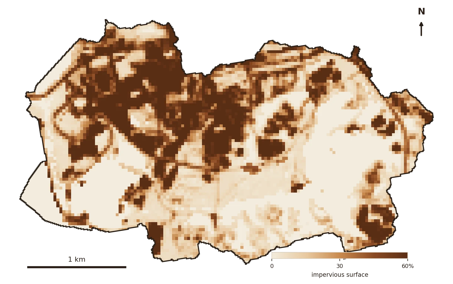
Impervious cover — the hard, water-shedding stuff — covers about 26% of the Hunnicutt watershed. That isn't just high; it's over a line. The Center for Watershed Protection's Impervious Cover Model marks two thresholds: streams begin to degrade past 10% hardening, and generally stop supporting healthy aquatic life past 25%. Hunnicutt crossed 10% long before this record begins, and crossed 25% around 2018.

Impervious cover, 1985–2023

Share of the 1,776-acre watershed that is impervious. Dashed line = the 25% "streams stop supporting healthy life" threshold (Center for Watershed Protection). Source: USGS EROS Annual NLCD Fractional Impervious Surface, 30 m.
Same region, same clay, very different water.

Atlas entry No. 01 — Lower Eighteenmile Creek, the next watershed over, sits at about 8% impervious: still below the first threshold. Hunnicutt, nine times smaller and far more built, is past the second. The two watersheds bracket the whole model.

Land-cover map of Hunnicutt, campus core in warm developed tones, forest in the southeast.
Land cover, 2023 · NLCD. The dark-red campus core is high-intensity development; green survives mostly in the southeast.
Impervious-surface map of Hunnicutt, darkest over the campus and downtown.
Impervious surface, 2023 · NLCD. Darkest brown is near-total pavement — the campus and downtown core.

Where the green went

Forest and farm, traded for pavement

Developed land went from about 57% of the watershed in 1985 to 76% in 2023. Over the same years forest fell from 25% to 15%, and the old pasture from 16% to 7%. Nearly everything that changed, changed into developed ground. Drag the slider; click a wedge to trace one class.

Hunnicutt Creek

Land cover by area · 2023

Lower Eighteenmile · No. 01

Composition, not size · same year
2023
Click any wedge to trace how that cover changed from 1985 to 2023.

Set against Eighteenmile, the contrast is stark: Hunnicutt's developed wedge (clay) fills three-quarters of the circle where Eighteenmile's is a third. This is what a fully urban watershed looks like next to a still-mixed one.

What the water does now

Small, hard, and flashy

The curve-number model puts numbers on the flashiness. Hunnicutt's runoff curve number rose from 69 to 71.5 as it hardened. Because it started high — a hard watershed has little green left to soak up rain — the everyday storms respond sharply:

Runoff volume per storm — 1985 vs 2023

Total runoff leaving the 1,776-acre watershed, by storm size. Curve-number model calibrated to USGS StreamStats (RCN 71.3); storm depths from NOAA Atlas 14. Acre-foot ≈ 326,000 gallons.
A 2-year storm now sheds about 22 acre-feet more than it did in 1985 — off just 2.8 square miles.

That's a 12.7% jump — a bigger step, in percentage terms, than Eighteenmile's 7.8%. The reason is exactly the hardening: a small watershed with little green left has nothing to absorb the difference, so more of every rain leaves as fast runoff, carrying whatever it picks up straight to the lake.

The hopeful part

Small enough to actually fix

A small watershed is a hard problem — there's little green left to work with — but also a tractable one. Two and a half square miles is a size a campus can change on purpose: green roofs, rain gardens, daylighted channels, restored headwater wetlands, roots put back in the ground.

And the work has already started. At the very top of the watershed, in the Botanical Garden, a student-run food forest is doing exactly this — slowing water, rebuilding soil, and holding rain where it lands at the creek's headwaters. Scale that thinking across 2.8 square miles and you could measurably change the water leaving Hunnicutt.

Slow it · spread it · sink it

The receipts

Every number, from open data

The watershed was delineated fresh from its Lake Hartwell outlet using USGS SS-Delineate; every figure is computed locally from public sources. Cross-check: our 2019 impervious estimate (25.3%) matches StreamStats' independent value (25.2%) to within a tenth of a point.

Watershed boundaryUSGS SS-Delineate v1, delineated from the pour point at the Lake Hartwell (Seneca arm) outlet — 2.78 sq mi.
Impervious & land coverUSGS EROS Annual NLCD Collection 1 — Fractional Impervious Surface and Land Cover, 30 m, 1985–2023.
Streams & terrainUSGS NHD flowlines; USGS 3DEP 1 m LiDAR hillshade.
Soils / hydrologic groupUSDA SSURGO via Soil Data Access — area-weighted (≈78% group B).
Runoff modelTR-55 / SCS Curve Number, calibrated to USGS StreamStats basin characteristics (RCN 71.3).
Design stormsNOAA Atlas 14 — 24-hr precipitation-frequency depths at the watershed.

Impairment context: Hunnicutt Creek is a small campus tributary within the Seneca River / Lake Hartwell system. A surface-temperature (heat) layer is in progress and will be added as the atlas grows.